Bing Maps and Bing Maps for Enterprise, Formerly Live Search Maps and Microsoft Virtual Earth


With Microsoft rolling out what it calls a decision engine, Bing, the Redmond-based software developer is announcing a few changes to Live Search Maps and Microsoft Virtual Earth. Just as Live Search is being replaced by Bing, so is Live Search Maps being replaced with Bing Maps and Microsoft Virtual Earth with Bing Maps for Enterprise.
Soon to be Bing Maps Technical Evangelist, Chris Pendleton, explains: “Live Search Maps was our consumer maps offering. This is the web site you go to for maps, aerial photos, directions, searching for points of interest and creating collections of your own personal data to store in the cloud. Live Search Maps is now called Bing Maps. Microsoft Virtual Earth was our enterprise mapping platform. This was the set of APIs you would leverage to embed maps into your web site along with overlay data in the form of pushpins, polygons, polylines, raster overlays, etc. etc. Microsoft Virtual Earth is now called Bing Maps for Enterprise.”
The move on Microsoft’s part is an obvious one: by bringing Live Search Maps and Virtual Earth under the Bring umbrella and by rebranding the two as Bing Maps and Bing Maps for Enterprise, it is emphasizing the fact that Virtual Earth is something for the corporate world. Virtual Earth has always been considered as an enterprise mapping platform by Microsoft, and nothing makes it more obvious than placing a “for Enterprise” tag in the title. Some things will go unchanged though, said Chris Pendleton, like MapPoint Web Service and Photosynth – MapPoint Web Service will continue to be called MapPoint Web Service and so will Photosynth.
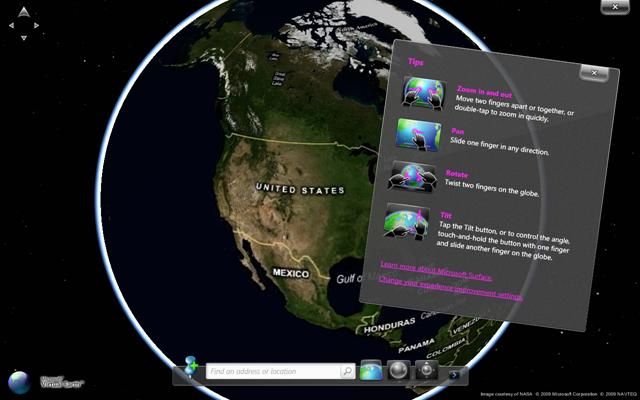
In related news, the recently announced Microsoft Touch Pack for Windows 7, a collection of multitouch-exclusive pieces of software; amongst them there is one called Microsoft Surface Globe that is powered by Virtual Earth. The Microsoft Surface Globe app, in a nutshell, allows you to navigate through a 3D version of the world, but Chris Pendleton comes with additional details.
“It’s a WPF application that integrates the Microsoft Virtual Earth 3D map control with the Surface multi-touch APIs,” he said. “It also goes full screen exclusive for a true gaming affect. You can annotate the map with your own information and use several different 3D pushpin icons available with the application. The navigation bar allows you to view the Earth orthographically or tilt it for a more oblique view. Also, built into the application is the ability to not only add your own pins, but export them (to a spreadsheet for example) so they can then be uploaded into Live Maps via the Collections Editor. The Road map style is also included, so you can see the vector roads as well, although Aerial is the default. The other built-in feature is the ability to search through Collections stored in Live Maps.”
Soon to be Bing Maps Technical Evangelist, Chris Pendleton, explains: “Live Search Maps was our consumer maps offering. This is the web site you go to for maps, aerial photos, directions, searching for points of interest and creating collections of your own personal data to store in the cloud. Live Search Maps is now called Bing Maps. Microsoft Virtual Earth was our enterprise mapping platform. This was the set of APIs you would leverage to embed maps into your web site along with overlay data in the form of pushpins, polygons, polylines, raster overlays, etc. etc. Microsoft Virtual Earth is now called Bing Maps for Enterprise.”
The move on Microsoft’s part is an obvious one: by bringing Live Search Maps and Virtual Earth under the Bring umbrella and by rebranding the two as Bing Maps and Bing Maps for Enterprise, it is emphasizing the fact that Virtual Earth is something for the corporate world. Virtual Earth has always been considered as an enterprise mapping platform by Microsoft, and nothing makes it more obvious than placing a “for Enterprise” tag in the title. Some things will go unchanged though, said Chris Pendleton, like MapPoint Web Service and Photosynth – MapPoint Web Service will continue to be called MapPoint Web Service and so will Photosynth.
In related news, the recently announced Microsoft Touch Pack for Windows 7, a collection of multitouch-exclusive pieces of software; amongst them there is one called Microsoft Surface Globe that is powered by Virtual Earth. The Microsoft Surface Globe app, in a nutshell, allows you to navigate through a 3D version of the world, but Chris Pendleton comes with additional details.
“It’s a WPF application that integrates the Microsoft Virtual Earth 3D map control with the Surface multi-touch APIs,” he said. “It also goes full screen exclusive for a true gaming affect. You can annotate the map with your own information and use several different 3D pushpin icons available with the application. The navigation bar allows you to view the Earth orthographically or tilt it for a more oblique view. Also, built into the application is the ability to not only add your own pins, but export them (to a spreadsheet for example) so they can then be uploaded into Live Maps via the Collections Editor. The Road map style is also included, so you can see the vector roads as well, although Aerial is the default. The other built-in feature is the ability to search through Collections stored in Live Maps.”